Imagine a map of the world, each country rising from the surface, growing arms and legs, and walking about. Each country free from its ties to Cartesian flatland, beginning to converse with its neighbors, stretching out, bickering, laughing. The landscape shifting. Taking the shape of a large and clumsy bear, Russia lumbers, pawing at the horizon. The other countries, some of them in the shape of kings and commanders, others as dogs and octopi, watch and brace themselves. This, is the curious world of anthropomorphic maps…
Anthropomorphic maps are maps depicting countries, landscapes or landmarks in humanised forms. Instead of illustrating the world in terms of physical geography, anthropomorphic maps use human stereotypes to assert nationalism or jingoism, or make a political statement, or portray national characteristics. They are maps made human. And are not, at times, for the faint-hearted…
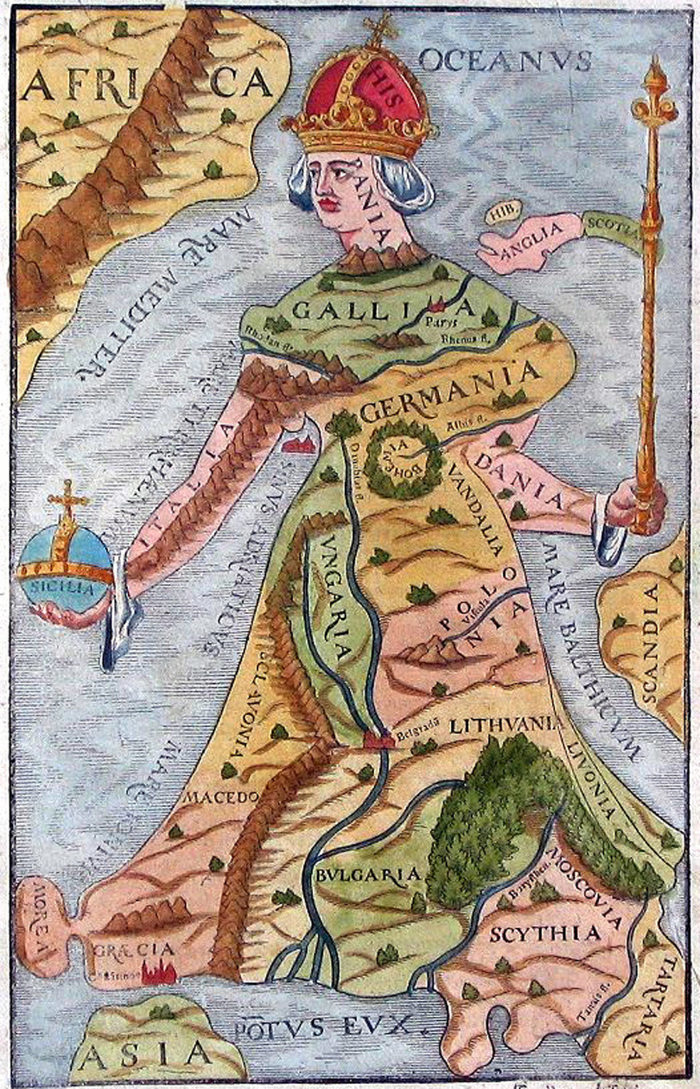
One of the most popular early anthropomorphic depictions was called the Europa Regina, or Queen Europe, and several were produced by different cartographers in the 1500s. Europe Regina represents the European continent as a queen with the Iberian continent as her crown, Bohemia as her heart, France as her upper body, and several Slavic countries as her lower body. The Europa Regina illustrates the political situation through the way the map was drawn. It portrays the dominance of the Holy Roman Empire under Charles V and the political influence of the Hapsburgs, thus France, Spain, and Bohemia all have prominent places in the map.The depictions of Europe as a queen or young maiden played an important part in cartography during the Renaissance. This is the Europa Prima Pars Terrae in Forma Virginis created by Protestant theologian Heinrich Bunting. Bunting’s depiction is larger and more sharply defined than other Europa Reginas but the concept is almost exactly the same; with the European continent portrayed in the shape of a queen with Spain as her crown, the upper body is France and Germany, and her gown reaching into to Russia.
Around Europe pretty much every national stereotype has been called in to play in the propaganda war surrounding Europe endless territorial battles. Such as in this selection from the First World War.
“Hark! hark! The dogs do bark!” by Walter Emanuel; London, G.W. Bacon & Co. 1914. The steamroller of Russia crashing into the dog-fight of Europe. The British naval mariner holding back the British bulldog about the attack the French poodle and the German daschhound… Every stereptype going! These aren’t the most subtle of maps, but they certainly pack a powerful propaganda punch.“European Revue – Kill That Eagle” by J. Amschewitz; London, pub. by “Geographica”, 1914. ‘John Bull’ on his way to deal with the German ‘eagle’ as the ‘bear’ stands ready to join the fray.
“The Insane Asylum (Old Song, New Tune)” by Louis Raemaekers 1915. In this map Britain morphs into a highland soldier leaping in to the eyeball-to-eyeball conflict between France and Germany.“Gedrängte Frühjahrsübersicht von Europa im Jahre 1915” roughly traslated as “Compact Overview of European Spring, 1915” by Lucas Gräfe; Hamburg, AK [pub.], 1915And just in case you thought that the satirical political maps of Europe finished with the First World War, here’s one in a similar vein , portraying European rivalry in football at the 2008 UEFA European Cup!