The São Francisco river was once a long, meandering, shallow river, nothing like the Xingó canyons formed hundreds of millions of years ago on the border between the states of Sergipe and Alagoas, where its waters today flow between rock walls up to 50 meters (m) high.
Over the last 90,000 years, in response to changes in rainfall patterns and vegetation on the riverbanks, the shape of the São Francisco river, known locally as “Velho Chico,” has changed significantly. The 2,863-kilometer (km) river cuts through 521 municipalities from its source in the Serra da Canastra Mountains of Minas Gerais.
When rain was more abundant between 90,000 and 66,000 years ago, the river carried large amounts of sediment and carved through the land. When sediment volumes were particularly high, sand was deposited on the riverbed and banks, creating an intertwined pattern of multiple channels flowing at the same time. When there was less sediment and more moderate rainfall between 66,000 and 39,000 years ago and between 19,000 and 9,000 years ago, it formed broad sinuous curves called meanders. Meandering rivers are common in tropical and subtropical environments, exemplified by the Purus and Juruá rivers in the Amazon, which are the most winding in the world, alongside the Mississippi in the USA.
The river’s current path, some 20 m below its old position, took shape around 5,000 years ago, according to sediment analyses conducted by researchers from the University of São Paulo (USP), São Paulo State University (UNESP), the Federal University of São Paulo (UNIFESP), and the Federal University of Alagoas (UFAL).
Geologist Patrícia Mescolotti points out that the method used to determine when sunlight last fell on the quartz crystals found in the sand on the riverbanks before they were covered by more recent sediment is limited to 90,000 years. “The river is likely older, but we cannot say for sure,” says the researcher, who has been working at the Federal University of Mato Grosso do Sul (UFMS) in Campo Grande since May 2022. Describing the river’s geomorphological dimensions in a January 2022 article in the Brazilian Journal of Geomorphology, geologists Landerlei Santos of UNESP and Edgardo Latrubesse of the Federal University of Goiás (UFG) observed that some of the floodplains may have formed at the end of the Pleistocene epoch, between 10,000 and 82,000 years ago.
During her PhD at UNESP in Rio Claro, under the guidance of geologist Mario Assine and UNIFESP geographer Fabiano Pupim, Mescolotti examined sediments collected from 51 points along the riverbank in Bahia and from dunes in the municipality of Xique-Xique, in Bahia (see picture). She also studied aerial photos and satellite images that showed the old riverbed — shaped like small horseshoes, and abandoned as the water found easier paths to follow — and helped to reconstitute the terraces (former floodplains), which extended beyond the old riverbanks.
“Despite the river being a symbol of the Northeast, the flow of the São Francisco appears to be controlled by the South American monsoon system [characterized by intense rainfall in the summer and dry winters], which takes water from the Amazon to the Southeast of Brazil,” explains Pupim. Unlike other large rivers, most of which are supplied by tributaries along their entire course, the São Francisco receives most of its water near its source, from tributaries such as the Rio das Velhas (the largest), the Paracatu, and the Urucuia. “As has been the case for thousands of years, around two-thirds of the river’s water continue to come from the region of the river’s source in Minas Gerais.” By the time it reaches the municipality of Januária, less than a thousand km from its source, the river already has almost 70% of its volume, as described in an article published in Quaternary Science Reviews in April 2021.
At the same time, USP geologist Cristiano Mazur Chiessi and colleagues studied the behavior of the São Francisco river basin by examining the proportion of two distinct forms of hydrogen and carbon in tree and grass remains accumulated in marine sediments, which they collected from depths of 1,897 m, less than 1 km from the river mouth on the border of Alagoas and Sergipe, in 2016. Their conclusions were similar to those of Pupim’s group: “Rainfall in the São Francisco river drainage basin, particularly at the headwaters and in the middle section, comes mainly from the Amazon,” says Chiessi. “We didn’t notice any significant long-term changes in the water source.”
The hydrogen and carbon distribution indicated periods of more or less intense rainfall in the São Francisco basin. “When the dry season was shorter, trees occupied a greater area in the Cerrado in the area of the river basin near the source. When dry seasons were longer, conversely, grasses predominated,” says USP geologist Jaqueline Quirino Ferreira, lead author of an article detailing the group’s results, published in Quaternary Science Reviews in March 2022.
An particular aspect of Velho Chico is that it crosses three natural environments — the Atlantic Forest, Cerrado (savanna), and Caatinga (semiarid scrublands). “Long rivers that flow from north to south or south to north generally cross more than one type of natural environment, such as the Paraná River, which cuts through the Atlantic Forest and southern Brazil and Argentina,” explains José Cândido Stevaux, a geologist from the Federal University of Mato Grosso do Sul (UFMS) in Três Lagoas who worked with Mescolotti.
São Francisco has one of the largest artificial lakes in the world, the 4,214 km2 Sobradinho dam reservoir, part of the power plant of the same name in northern Bahia. This and four other large hydroelectric power plants (Três Marias, Luís Gonzaga, Xingó, and Paulo Afonso) alter the width, depth, speed, and flow of the river, and consequently change the lives of residents in nearby towns.
“The effects of the dams are clearer near the mouth, especially in three municipalities in Alagoas (Piranhas, Pão de Açúcar, and Traipu) and one in Sergipe (Propriá),” observes geographer Genisson Panta, a PhD student at the Federal University of Pernambuco (UFPE) and high school teacher at a state public school in Maceió. Motivated by Stevaux, who he met at a conference in Fortaleza, Ceará, he has been studying these changes since 2019 and presented them in an article published in the Journal of South American Earth Sciences in January.
Walter Antonio do Livramento / Wikimedia CommonsIn Piranhas, Alagoas, the river has become shallower in response to the increased flow caused by the Xingó damWalter Antonio do Livramento / Wikimedia Commons
Based on field research and the analysis of data from hydrometric stations that measure the river’s flow, he concluded that in Piranhas, the depth decreased in response to an increased flow caused by the Xingó hydroelectric plant, built on the border between Alagoas and Sergipe in 1994. “Before, there was a layer of sediment at the bottom of the river, the depth of which was adjusted depending on the flow rate,” he says. When the dam was built, the sediment layer was removed, the bed rocks were exposed, and the river could only make lateral adjustments, increasing its width.
In the region between Propriá in Sergipe and Porto Real do Colégio in Alagoas, the river’s banks widened by 250 m from 1969 to 2022. “This is a very high erosion rate, around 5 m per year,” Panta emphasizes. According to him, erosion is not continuous — it is episodic. “A single flood can wash away tons of sediment.”
In Propriá, the river’s flow was maintained, but its width increased from 600 m to 720 m after the Xingó power plant began operating 150 km downstream in 1994. In Carinhanha, southwest of Bahia, the depth of the river increased from 2 m to 3 m after the construction of the Três Marias dam 700 km to the south, which was also completed in 1994. “The figures are similar to those of other tropical river systems, such as Tocantins-Araguaia and Paraná,” he noted.
In Piaçabuçu, a municipality in Alagoas located 10 km from the river mouth, an unusual number of teenagers and adults suffered hypertension, the cause of which was discovered in 2017: during a drought, seawater flowed back into the river and people consumed untreated brackish water. “The sea advances more easily into the river mouth now because since the dams were built, the river flow is controlled by the demand for electricity,” says Panta.
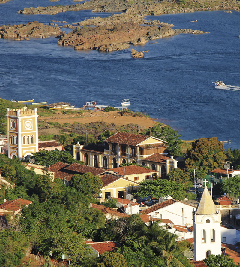
Given its current name by Italian explorer Américo Vespúcio (1454–1512) in 1501 and still today the stage for events such as a boat procession in Penedo, Alagoas, every January, the São Francisco continues to be transformed by both human and natural forces. One ongoing major project is a transfer of its waters, started in 2007 and partially completed in 2022, through the construction of 700 km of concrete canals to supply farms and residents in the interior of northeastern Brazil.
“To be successful, a strong plan is needed on how much water to take and how to distribute it, perhaps not taking it at certain times of the year so as not to harm the river,” says Stevaux. “Hundreds of rivers have been diverted around the world. Dams cause much worse impacts.”
Shifting dunes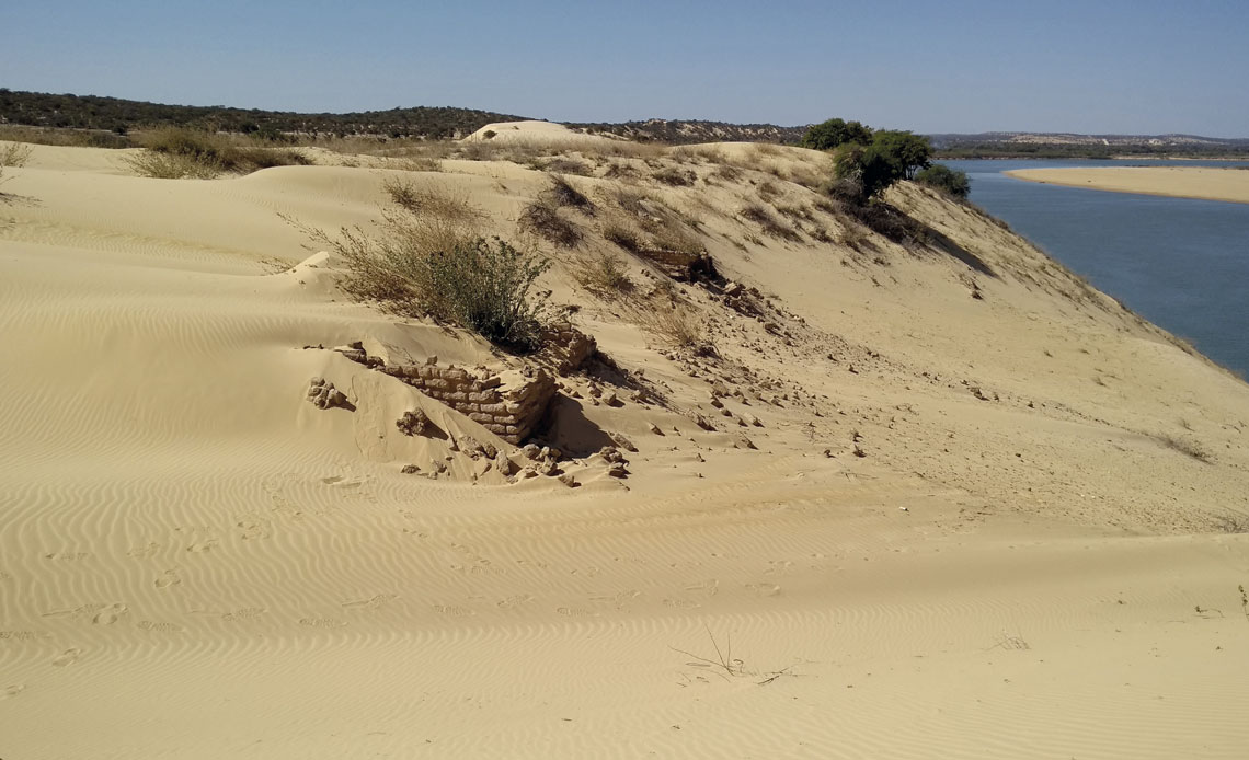
Patricia Colombo MescolottiNow divided by rivers, the dunes of Xique-Xique once formed a singular areaPatricia Colombo Mescolotti
Based on analyses of sand collected from depths of up to 2 meters, the dunes in Xique-Xique, Bahia, which today occupy an area of 8,000 km2, began to be formed by sand from the São Francisco river at least 150,000 years ago, when the climate was dry, as described in an article published in the journal Geomorphology in January.
“In several places, the dunes were once more extensive and formed a single area, today divided by the rivers that flow into the São Francisco,” says Patricia Mescolotti, from UFMS. Different reptile and mammal species live on either side, differentiated from a single species.
The dunes, up to 30 m high, shift in response not only to the river sands that feed them, but also to the removal of vegetation from the riverbanks and the intensity of droughts, according to a paper published in Geomorphology by Santos and Latrubesse in November 2021. They observed that the dunes migrated an average of 15 meters per year between 2002 and 2010 and 9.4 meters per year from 2010 to 2019.
Roughly 15 years ago, sand from the Geleia dunes covered the roads and houses in the village of Icatu, Bahia, forcing inhabitants to move to previously settled dunes.
Projects
1. Historical perspectives on critical thresholds of the climate system: The Amazon rainforest and the Atlantic Meridional Overturning Circulation (PPTEAM) (nº 18/15123-4); Grant Mechanism Research Grant ‒ Program for Research on Global Climate Change ‒ Young Investigator Award; Principal Investigator Cristiano Mazur Chiessi (USP); Investment R$3,123,253.45.
2. Assessing the effects of past and future climate changes on Amazonian biodiversity (CLAMBIO) (nº 19/24349-9); Grant Mechanism Research Grant ‒ Biota Program; Principal Investigator Cristiano Mazur Chiessi (USP); Investment R$230,317.74.
Scientific articles
FERREIRA, J. Q. et al. Changes in obliquity drive tree cover shifts in eastern tropical South America. Quaternary Science Reviews. vol. 279, 107402. mar. 1, 2022.
MESCOLOTTI, P. C. et al. Fluvial aggradation and incision in the Brazilian tropical semi-arid: Climate-controlled landscape evolution of the São Francisco river. Quaternary Science Reviews. vol. 263, 106977. july 1, 2021.
MESCOLOTTI, P. C. et al. The largest Quaternary inland eolian system in Brazil: Eolian landforms and activation/stabilization phases of the Xique-Xique dune field. Geomorphology. vol. 420, 108516. jan. 1, 2023.
PANTA, G. et al. Morphohydraulic of a dam-impacted large river: The São Francisco River, Brazil. Journal of South American Earth Sciences. vol. 121, 104167. jan. 2023.
SANTOS, L.A.; LATRUBESSE, E.M. Unidades geomorfológicas da planície aluvial do Médio Rio São Francisco, Nordeste do Brasil. Revista Brasileira de Geomorfologia. vol. 23, no. 1, pp. 1097–115. jan. 13, 2022.
SANTOS, L.A.; LATRUBESSE, E.M. Aeolian mobility in the Middle São Francisco Dune Field, Northeast Brazil, as a response to Caatinga’s droughts and land-use changes. Geomorphology. vol. 393, 107940. nov. 15, 2021.
Republish

