I first became aware of the Volcan Paricutin in early 1995 whilst perusing a copy of the World Almanac. It was listed as one of the Seven Natural Wonders of the World. When I realized that it was located less than five hours’ drive from where I was living in the state of Jalisco, I immediately got in my car and drove to Angahuan to see it for myself. I made a return visit to the volcano ten years later, accompanied by my sister, who can be seen crossing the lava field in the second photo from the top. Details have been updated as of March 2020.

Yours truly crossing the lava field to Paricutin in 2005.
Distance: 12.4 miles (20 km)
Avg.Time: 5-7 hours
Start / Finish:
- Out-and-back journey from the Centro Turistico de Angahuan.
Getting There & Away:
- There are regular 2nd class buses to Angahuan from Uruapan. The 20 miles (32 km) trip takes about one hour.
- On both occasions I visited Paricutin I arrived by private transport.
Season:
- Possible any time of year.
Maps / Info:
- The Centro Turistico de Angahuan is a good source of up-to-date information in regards to the Volcan Paricutin. If you have come by private transport, I found this to be a safe place to leave your vehicle for the day.
- On both my Paricutin hikes I never had a map. From the Centro Turistico you can see the Volcano SSE of where you leave your car, and I basically made a beeline from there. However, in updating this article in March 2020, I noticed that AllTrails has a GPS track for the route. It differs slightly from my own journey, in that it returns to Angahuan via a dirt road which is situated east of the lava field trail.

Crossing the lava field towards the volcano.

Looking back toward Angahuan from the crater rim.
History:
In 1943 the Volcan Paricutin emerged from a cornfield in Michoacan, Mexico. Over the next nine years, it erupted continuously, affording vulcanologists the first-ever opportunity to document the full life cycle of an eruption of this type. Paricutin has subsequently been recognized as one of the world’s Seven Natural Wonders. The other honorees are the Grand Canyon, Victoria Falls, Rio de Janeiro Harbor, Great Barrier Reef, Mount Everest, and the Aurora of the Arctic and Antarctic regions.
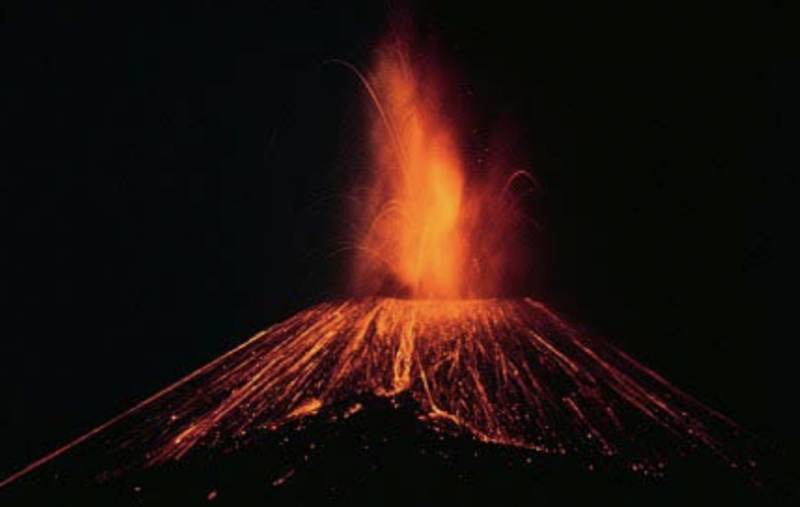
Volcan Paricutin (1952) (Photo from Wikimedia Commons)
Route / Conditions:
-
- Departing from the Central Turistico, drop down into the forest below and head SSE along forest roads. If in doubt, ask locals to point you in the right direction.
- Within an hour or so, you will clear the forest and reach the edge of the lava field, after which the volcano will always be in sight. From this point, the route to the volcano is marked by paint splashes and the occasional rock cairn.
- You can either return via the same lava field trail or alternatively on the eastern dirt road shown on the AllTrails GPS route.

Inside the crater of Volcan Paricutin.
- It is well worth finding this marked route. If you don’t, as was the case when I first visited in 1995, it’s a long, hard slog across the lava field.
- Either on the way out or on the return journey, be sure to visit the memorable Templo San Juan Parangaricutiro (see photos). This half-buried church situated on the edge of the lava field is about 45 minutes walk from the village of Angahuan.

Templo San Juan Parangaricutiro